
")


Altimeter Ler Live Gps Geotracker v2.4 Premium
Premium / Paid features Unlocked
Location Maps work
Debug code removed
Apk signature changed
Languages: Multi Languages
CPU architectures: arm64-v8a, armeabi-v7a, x86, x86_64
Screen DPIs: 120dpi, 160dpi, 240dpi, 320dpi, 480dpi, 640dpi
Requirements: 4.1 and up
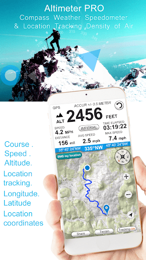
Overview: Ler is a best altimeter app for professionals as well as amateurs. Modern Altimeter GPS+ app is for folks who care for hiking and biking in mountainous terrain. GPS is getting very accurate in terms of distance indication. This app has a creative and user-friendly style design, simple and comprehensive functionalities.
Modern Altimeter GPS+ app is for folks who care for hiking and biking in mountainous terrain. GPS is getting very accurate in terms of distance indication. The choice between unit system is perhaps an important thing, just for your convenience the app is being equipped with both of them (Imperial and Metric). Surprisingly strong barometer measures the weight of the air pressure above a given point and determines elevation of two points.
This app has a creative and user-friendly style design, simple and comprehensive functionalities. Features included
– Imperial and Metric unit settings.
– GPS accuracy indicator.
– GPS distance accuracy indicator.
– Density of air , indicator.
Search any place and drop search pin with place info.
Built in library
Map integration
– GOOGLE maps
– Satellite maps mode.
– Hybrid maps mode.
– Standard maps mode.
– Terrain maps mode.
– Tracking location changes trajectory.
Compass
– Compass with camera
– Take a pictures with coordinates
– Shows device real-time orientation to magnetic fields.
– Ability to switch between true and magnetic North.
– Location coordinates (longitude, latitude).
– Course
Track information
– Time elapsed.
– Distance.
– Average speed.
– Max speed.
– Altitude.
Tracking
– Speed tracking in mph or km/h based on MPH or KM/H mode.
– Distance tracking in miles or kilometers based on MPH or KM/H mode.
– Time tracking.
– Longitude, latitude coordinates.
– Save locations drop a pin
Weather
Temperature information.
Wind
Visibility
Sunrise, Sunset
High/Low Temperature.
Ability to switch between Celsius and Fahrenheit.
What’s New:
A few bugs have been fixed
performance improvements

* Comment obtenir le lien de téléchargement ?
* How do I get the download link?
 viewtopic.php?f=222&t=9976
* Vous êtes un visiteur? Comment s'inscrire sur ce forum
* You are a visitor? How to register on this forum
viewtopic.php?f=77&t=296